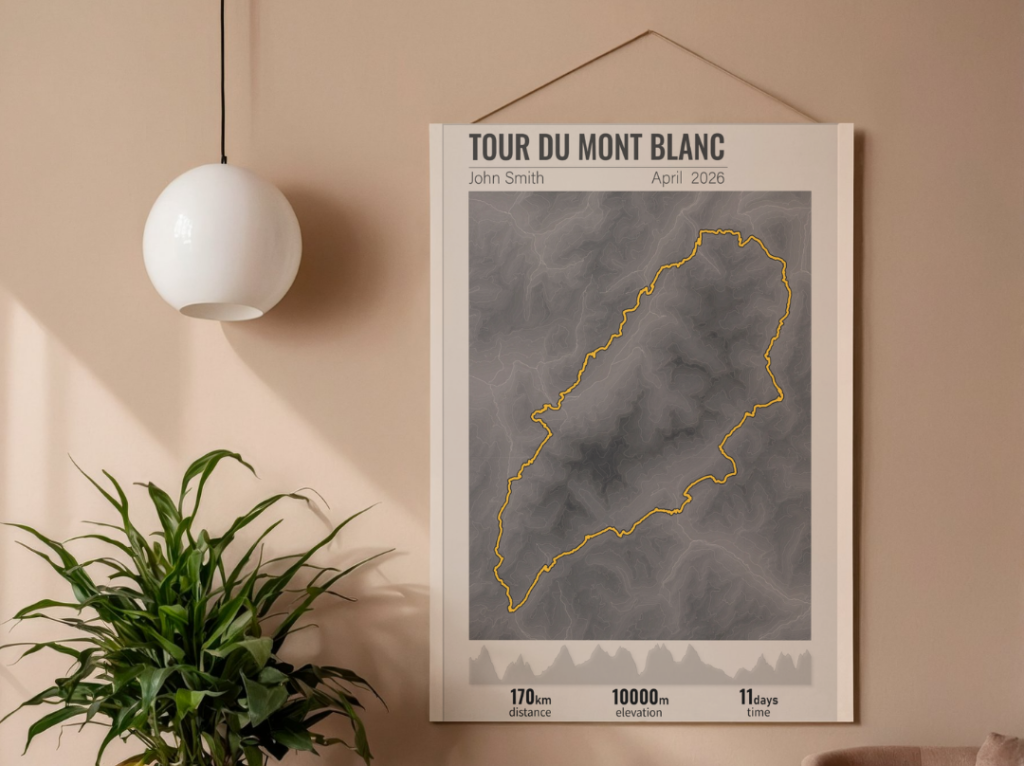
admin

test map

Rural Pharmacy Placement Map Click a pin to view pharmacy details and submit a placement request Showing 56 pharmacies Legend Placement pharmacy Intern positions available Placement request × Your details First name * Last name * Email * Mobile * University * Year of study— Select —3rd year4th year5th yearGraduate / Intern Student ID Placement […]

test map Read More »

Interactive Municipality Monitoring Dashboard

Overview This project is an interactive web-based dashboard designed to visualize and monitor project activities across multiple municipalities. The dashboard combines a custom SVG map with live data from Google Sheets, providing stakeholders with an intuitive way to explore field updates and progress reports. Live Demo The solution displays municipalities on an interactive map and

Interactive Municipality Monitoring Dashboard Read More »

Nuremberg Airport Video Animation

This project is a cinematic airport animation of Nuremberg Airport created using Google Earth Studio and refined in Adobe After Effects.The animation highlights the airport’s layout, runways, terminal infrastructure, and surrounding environment through smooth aerial camera movements and dynamic visual transitions. Designed as a portfolio piece, the project demonstrates skills in GIS-based visualization, motion design,

Nuremberg Airport Video Animation Read More »

Interactive U.S. States and Counties Map

This interactive map visualizes administrative divisions of the United States, including all states and their respective counties. The application is built using modern JavaScript mapping libraries and integrates external datasets to enhance interactivity and data display. Technologies Used: Key Functionality: Data Content: The map displays the U.S. states and counties, sourced from custom Mapbox vector

Interactive U.S. States and Counties Map Read More »

Interactive Map of Germany

Technologies Used: Main Functionality:This project presents an interactive SVG map of Germany’s administrative regions (states). Each state is represented as an SVG <path> element, styled with custom CSS. The map supports several interactive features: Map Content:The map depicts the federal states of Germany (“Bundesländer”). For example, the region of Hamburg is included as an SVG

Interactive Map of Germany Read More »

Interactive Map of Company Branch Managers

This project is an interactive web-based map that visualizes the geographic locations of branch managers for a U.S.-based company. The map is implemented using Leaflet.js, a lightweight and open-source JavaScript library for mobile-friendly interactive maps. It also incorporates the Leaflet.markercluster plugin to efficiently handle large numbers of markers through clustering. Technologies Used Key Features Map

Interactive Map of Company Branch Managers Read More »

Interactive Map of Historical Administrative Units of Jutland (Denmark)

Technologies: Main Functionality: Map Content Description: This interactive map represents the historical administrative units of Jutland (Denmark). It includes names and borders of regions and provides links to informational pages about each region. The visual design features contrasting colors to highlight areas and hover effects to enhance interactivity. Summary: This project serves as an example

Interactive Map of Historical Administrative Units of Jutland (Denmark) Read More »